Florynka
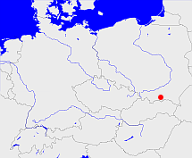
Diese Karte zeigt die Position oder den Umriss des Objekts. Haben Sie einen Fehler entdeckt? Dann würden wir uns über eine Nachricht freuen.
Übergeordnete Objekte
Legende
| | politische Verwaltung |
| | kirchliche Verwaltung |
| | gerichtliche Verwaltung |
| | Wohnplatz |
| | geographische Typen |
| | Verkehrswesen |
Übergeordnete Objekte
- Grybów (Landgemeinde PL)
- Powiat nowosądecki (Landkreis)
- Województwo małopolskie (Wojewodschaft)
- Polen (Dritte Republik), Polen, Poland (Third Republic), Polska - III Rzeczpospolita, La Pologne - IIIe République, Третья Речь Посполитая, Polaca - Tercera República (Republik)
- Europäische Wirtschaftsgemeinschaft, Europäische Gemeinschaft, Europäische Union, Evropské hospodářské společenství, Euroopan talousyhteisö, Európske hospodárske spoločenstvo, Communauté économique européenne, Comhphobal Eacnamaíochta na hEorpa, Europese Economische Gemeenschap, European Economic Community, Comunità Economica Europea, Comunidad Económica Europea, Europese Gemeenschap, Evropské společenství, Communauté européenne, Európske spoločenstvo, Comhphobal Eorpach, Comunità Europea, Comunidad Europea, European Community, Euroopan Yhteisö, Evropská unie, Unione Europea, Euroopan Unioni, Aontais Eorpaigh, European Union, Unión Europea, Europese Unie, Union européenne, Európska únia (Staatenbund)
- Vereinte Nationen, Verenigde Naties, Организация Объединённых Наций, Organisation des Nations unies, 联合国, Organización de las Naciones Unidas, United Nations, الأمم المتحدة, Organizácia Spojených národov (Staatenbund)
- Grybów (Bezirkshauptmannschaft)
Übergeordnete Objekte
| Name |
Zeitraum |
Typ |
Quelle |
|
Grybów
|
(1999 -) |
Landgemeinde PL
|
Quelle
|
|
Grybów
|
|
Bezirkshauptmannschaft
|
|
Untergeordnete Objekte
| Name |
Typ |
GOV-Kennung |
Zeitraum |
| Wołoszczyny |
FörstereiOrtsteil
|
WOOYNYKN09LN |
(1999 -) |
Quicktext
ENGFEN_W8901
	has 1895-12-02 area 2.79 sagt source_1023281 (p. 220/221),
	has 1895-12-02 population 295 sagt source_1023281 (p. 220/221),
	has 1910-12-01 population 301 sagt source_265044,
	has 1925 households 82 sagt source_1023282 (Seite 23),
	has 1925-06-16 population 348 sagt source_1023282 (p. 23),
	has 1931 area 2.796 sagt source_1023282 (p. 23),
	has 1933 population 336 sagt source_190312,
	has 1939 population 364 sagt source_190312,
	has 1961 population 50 sagt source_379404,
	has 1987 population 0 sagt source_320250,
	has URL  http://en.wikipedia.org/wiki/Florynka,
	has URL  https://de.wikipedia.org/wiki/Engertshofen,
	has external reference  BLO:42150,
	has external reference  SIMC:0427187,
	has external reference  SIMC:0910630,
	has external reference  geonames:2930157,
	has external reference  geonames:772507,
	has external reference  wikidata:Q545967,
	has from 1945 name (in pol) Marcinowice sagt source_149286,
	has from 1993-07-01 postal code 86424,
	has name (in deu) Engertshofen,
	has name (in pol) Florynka,
	has until 1945 name (in deu) Merzdorf,
	has until 1993-06-30 postal code W8901,
	has w-number 51131,
	is (in deu) Dorf,
	is from 1935-04-01 (in deu) Gemeinde sagt source_190312,
	is from 1945 until 1975 part of object_291537 sagt source_149286,
	is from 1950 until 1952-01-23 part of object_1176762 sagt source_1048536 (1950 - S. 97),
	is from 1952-01-24 part of object_1176630 sagt source_1048536 (1952 - S. 48),
	is from 1972-07-01 part of object_300838,
	is from 1999 part of object_1072580 sagt source_1079298,
	is part of object_1072430,
	is part of object_1088519 sagt source_379404 (Sp. 917),
	is part of object_306267,
	is until 1935-03-31 (in deu) Landgemeinde sagt source_265044,
	is until 1945 part of object_190093 sagt source_1023281 sagt source_1023282 sagt source_149286 sagt source_190312 sagt source_265044,
	is until 1945 part of object_285677 sagt source_1023281 (Seite 220/221) sagt source_1023282 (p. 23),
	is until 1950 part of object_1087422 sagt source_1048536 (1950 - S. 97),
	is until 1972-06-30 part of object_1176637,
	located at 48.3457°N 10.5542°O,
	located at 49.5536°N 20.9839°O;
