Stankowitz, Staňkovice
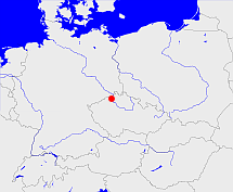
Diese Karte zeigt die Position oder den Umriss des Objekts. Haben Sie einen Fehler entdeckt? Dann würden wir uns über eine Nachricht freuen.
Übergeordnete Objekte
Legende
| | politische Verwaltung |
| | kirchliche Verwaltung |
| | gerichtliche Verwaltung |
| | Wohnplatz |
| | geographische Typen |
| | Verkehrswesen |
Übergeordnete Objekte
- Stankowitz, Staňkovice (Gemeinde)
- Leitmeritz, Litoměřice (Bezirkshauptmannschaft)
- Aussiger Region, Ústecký kraj (Region)
- Tschechische Republik, Tschechien, República Checa, Czech Republic, Czechia (Czech Republic), Česká republika, Tsjechië, Czechia, République tchèque (Republik)
- Europäische Wirtschaftsgemeinschaft, Europäische Gemeinschaft, Europäische Union, Evropské hospodářské společenství, Euroopan talousyhteisö, Európske hospodárske spoločenstvo, Communauté économique européenne, Comhphobal Eacnamaíochta na hEorpa, Europese Economische Gemeenschap, European Economic Community, Comunità Economica Europea, Comunidad Económica Europea, Europese Gemeenschap, Evropské společenství, Communauté européenne, Európske spoločenstvo, Comhphobal Eorpach, Comunità Europea, Comunidad Europea, European Community, Euroopan Yhteisö, Evropská unie, Unione Europea, Euroopan Unioni, Aontais Eorpaigh, European Union, Unión Europea, Europese Unie, Union européenne, Európska únia (Staatenbund)
- Vereinte Nationen, Verenigde Naties, Организация Объединённых Наций, Organisation des Nations unies, 联合国, Organización de las Naciones Unidas, United Nations, الأمم المتحدة, Organizácia Spojených národov (Staatenbund)
- Böhmen, Země Česká, Bohemia, Království české (Herzogtum Königreich Land)
- Heiliges Römisches Reich, Heiliges Römisches Reich deutscher Nation, Heiliges Römisches Reich, Sacrum Imperium, Sacrum Romanum Imperium, Sacrum Romanum Imperium Nationis Germanicæ (Königreich Kaiserreich)
- Reichsprotektorat Böhmen und Mähren, Protektorát Čechy a Morava (Protektorat)
- Tschechoslowakei, Tschecho-Slowakische Republik, Tschechoslowakei, Tschechoslowakische Republik, Tschechoslowakische Sozialistische Republik, Tschechische und Slowakische Föderative Republik, Tschechoslowakei, Československo, Československo, Česko-Slovenská Republika (ČSR), Česko-Slovenská Republika (ČSR), Československo, Československá republika, Československá Republika (ČSR), Czechoslovak Republic, Československá socialistická republika (ČSSR), Česká a Slovenská Federativní Republika (ČSFR), Česká a Slovenská Federatívna Republika (ČSFR), Tsjecho-Slowakije, Tsjechoslowakije (Republik Republik)
- Tschechoslowakei, Tschecho-Slowakische Republik, Tschechoslowakei, Tschechoslowakische Republik, Tschechoslowakische Sozialistische Republik, Tschechische und Slowakische Föderative Republik, Tschechoslowakei, Československo, Československo, Česko-Slovenská Republika (ČSR), Česko-Slovenská Republika (ČSR), Československo, Československá republika, Československá Republika (ČSR), Czechoslovak Republic, Československá socialistická republika (ČSSR), Česká a Slovenská Federativní Republika (ČSFR), Česká a Slovenská Federatívna Republika (ČSFR), Tsjecho-Slowakije, Tsjechoslowakije (Republik Republik)
- Kaiserthum Österreich, Cisleithanien, Österreichische Länder, Impero Austriaco, Předlitavsko (Kaiserreich Reichshälfte)
- Aussig, Ústí nad Labem (Regierungsbezirk)
- Ploschkowitz, Ploskovice, Ploškovice (Gemeinde)
- Leitmeritz, Litoměřice (Bezirkshauptmannschaft)
- Aussiger Region, Ústecký kraj (Region)
- Tschechische Republik, Tschechien, República Checa, Czech Republic, Czechia (Czech Republic), Česká republika, Tsjechië, Czechia, République tchèque (Republik)
- Europäische Wirtschaftsgemeinschaft, Europäische Gemeinschaft, Europäische Union, Evropské hospodářské společenství, Euroopan talousyhteisö, Európske hospodárske spoločenstvo, Communauté économique européenne, Comhphobal Eacnamaíochta na hEorpa, Europese Economische Gemeenschap, European Economic Community, Comunità Economica Europea, Comunidad Económica Europea, Europese Gemeenschap, Evropské společenství, Communauté européenne, Európske spoločenstvo, Comhphobal Eorpach, Comunità Europea, Comunidad Europea, European Community, Euroopan Yhteisö, Evropská unie, Unione Europea, Euroopan Unioni, Aontais Eorpaigh, European Union, Unión Europea, Europese Unie, Union européenne, Európska únia (Staatenbund)
- Vereinte Nationen, Verenigde Naties, Организация Объединённых Наций, Organisation des Nations unies, 联合国, Organización de las Naciones Unidas, United Nations, الأمم المتحدة, Organizácia Spojených národov (Staatenbund)
- Böhmen, Země Česká, Bohemia, Království české (Herzogtum Königreich Land)
- Heiliges Römisches Reich, Heiliges Römisches Reich deutscher Nation, Heiliges Römisches Reich, Sacrum Imperium, Sacrum Romanum Imperium, Sacrum Romanum Imperium Nationis Germanicæ (Königreich Kaiserreich)
- Reichsprotektorat Böhmen und Mähren, Protektorát Čechy a Morava (Protektorat)
- Tschechoslowakei, Tschecho-Slowakische Republik, Tschechoslowakei, Tschechoslowakische Republik, Tschechoslowakische Sozialistische Republik, Tschechische und Slowakische Föderative Republik, Tschechoslowakei, Československo, Československo, Česko-Slovenská Republika (ČSR), Česko-Slovenská Republika (ČSR), Československo, Československá republika, Československá Republika (ČSR), Czechoslovak Republic, Československá socialistická republika (ČSSR), Česká a Slovenská Federativní Republika (ČSFR), Česká a Slovenská Federatívna Republika (ČSFR), Tsjecho-Slowakije, Tsjechoslowakije (Republik Republik)
- Tschechoslowakei, Tschecho-Slowakische Republik, Tschechoslowakei, Tschechoslowakische Republik, Tschechoslowakische Sozialistische Republik, Tschechische und Slowakische Föderative Republik, Tschechoslowakei, Československo, Československo, Česko-Slovenská Republika (ČSR), Česko-Slovenská Republika (ČSR), Československo, Československá republika, Československá Republika (ČSR), Czechoslovak Republic, Československá socialistická republika (ČSSR), Česká a Slovenská Federativní Republika (ČSFR), Česká a Slovenská Federatívna Republika (ČSFR), Tsjecho-Slowakije, Tsjechoslowakije (Republik Republik)
- Kaiserthum Österreich, Cisleithanien, Österreichische Länder, Impero Austriaco, Předlitavsko (Kaiserreich Reichshälfte)
- Aussig, Ústí nad Labem (Regierungsbezirk)
- Schüttenitz, Schüdenitz, Žitenice (Gemeinde)
- Leitmeritz, Litoměřice (Bezirkshauptmannschaft)
- Aussiger Region, Ústecký kraj (Region)
- Tschechische Republik, Tschechien, República Checa, Czech Republic, Czechia (Czech Republic), Česká republika, Tsjechië, Czechia, République tchèque (Republik)
- Europäische Wirtschaftsgemeinschaft, Europäische Gemeinschaft, Europäische Union, Evropské hospodářské společenství, Euroopan talousyhteisö, Európske hospodárske spoločenstvo, Communauté économique européenne, Comhphobal Eacnamaíochta na hEorpa, Europese Economische Gemeenschap, European Economic Community, Comunità Economica Europea, Comunidad Económica Europea, Europese Gemeenschap, Evropské společenství, Communauté européenne, Európske spoločenstvo, Comhphobal Eorpach, Comunità Europea, Comunidad Europea, European Community, Euroopan Yhteisö, Evropská unie, Unione Europea, Euroopan Unioni, Aontais Eorpaigh, European Union, Unión Europea, Europese Unie, Union européenne, Európska únia (Staatenbund)
- Vereinte Nationen, Verenigde Naties, Организация Объединённых Наций, Organisation des Nations unies, 联合国, Organización de las Naciones Unidas, United Nations, الأمم المتحدة, Organizácia Spojených národov (Staatenbund)
- Böhmen, Země Česká, Bohemia, Království české (Herzogtum Königreich Land)
- Heiliges Römisches Reich, Heiliges Römisches Reich deutscher Nation, Heiliges Römisches Reich, Sacrum Imperium, Sacrum Romanum Imperium, Sacrum Romanum Imperium Nationis Germanicæ (Königreich Kaiserreich)
- Reichsprotektorat Böhmen und Mähren, Protektorát Čechy a Morava (Protektorat)
- Tschechoslowakei, Tschecho-Slowakische Republik, Tschechoslowakei, Tschechoslowakische Republik, Tschechoslowakische Sozialistische Republik, Tschechische und Slowakische Föderative Republik, Tschechoslowakei, Československo, Československo, Česko-Slovenská Republika (ČSR), Česko-Slovenská Republika (ČSR), Československo, Československá republika, Československá Republika (ČSR), Czechoslovak Republic, Československá socialistická republika (ČSSR), Česká a Slovenská Federativní Republika (ČSFR), Česká a Slovenská Federatívna Republika (ČSFR), Tsjecho-Slowakije, Tsjechoslowakije (Republik Republik)
- Tschechoslowakei, Tschecho-Slowakische Republik, Tschechoslowakei, Tschechoslowakische Republik, Tschechoslowakische Sozialistische Republik, Tschechische und Slowakische Föderative Republik, Tschechoslowakei, Československo, Československo, Česko-Slovenská Republika (ČSR), Česko-Slovenská Republika (ČSR), Československo, Československá republika, Československá Republika (ČSR), Czechoslovak Republic, Československá socialistická republika (ČSSR), Česká a Slovenská Federativní Republika (ČSFR), Česká a Slovenská Federatívna Republika (ČSFR), Tsjecho-Slowakije, Tsjechoslowakije (Republik Republik)
- Kaiserthum Österreich, Cisleithanien, Österreichische Länder, Impero Austriaco, Předlitavsko (Kaiserreich Reichshälfte)
- Aussig, Ústí nad Labem (Regierungsbezirk)
- Stankowitz, Staňkovice (Gemeinde)
- Leitmeritz, Litoměřice (Bezirkshauptmannschaft)
- Aussiger Region, Ústecký kraj (Region)
- Tschechische Republik, Tschechien, República Checa, Czech Republic, Czechia (Czech Republic), Česká republika, Tsjechië, Czechia, République tchèque (Republik)
- Europäische Wirtschaftsgemeinschaft, Europäische Gemeinschaft, Europäische Union, Evropské hospodářské společenství, Euroopan talousyhteisö, Európske hospodárske spoločenstvo, Communauté économique européenne, Comhphobal Eacnamaíochta na hEorpa, Europese Economische Gemeenschap, European Economic Community, Comunità Economica Europea, Comunidad Económica Europea, Europese Gemeenschap, Evropské společenství, Communauté européenne, Európske spoločenstvo, Comhphobal Eorpach, Comunità Europea, Comunidad Europea, European Community, Euroopan Yhteisö, Evropská unie, Unione Europea, Euroopan Unioni, Aontais Eorpaigh, European Union, Unión Europea, Europese Unie, Union européenne, Európska únia (Staatenbund)
- Vereinte Nationen, Verenigde Naties, Организация Объединённых Наций, Organisation des Nations unies, 联合国, Organización de las Naciones Unidas, United Nations, الأمم المتحدة, Organizácia Spojených národov (Staatenbund)
- Böhmen, Země Česká, Bohemia, Království české (Herzogtum Königreich Land)
- Heiliges Römisches Reich, Heiliges Römisches Reich deutscher Nation, Heiliges Römisches Reich, Sacrum Imperium, Sacrum Romanum Imperium, Sacrum Romanum Imperium Nationis Germanicæ (Königreich Kaiserreich)
- Reichsprotektorat Böhmen und Mähren, Protektorát Čechy a Morava (Protektorat)
- Tschechoslowakei, Tschecho-Slowakische Republik, Tschechoslowakei, Tschechoslowakische Republik, Tschechoslowakische Sozialistische Republik, Tschechische und Slowakische Föderative Republik, Tschechoslowakei, Československo, Československo, Česko-Slovenská Republika (ČSR), Česko-Slovenská Republika (ČSR), Československo, Československá republika, Československá Republika (ČSR), Czechoslovak Republic, Československá socialistická republika (ČSSR), Česká a Slovenská Federativní Republika (ČSFR), Česká a Slovenská Federatívna Republika (ČSFR), Tsjecho-Slowakije, Tsjechoslowakije (Republik Republik)
- Tschechoslowakei, Tschecho-Slowakische Republik, Tschechoslowakei, Tschechoslowakische Republik, Tschechoslowakische Sozialistische Republik, Tschechische und Slowakische Föderative Republik, Tschechoslowakei, Československo, Československo, Česko-Slovenská Republika (ČSR), Česko-Slovenská Republika (ČSR), Československo, Československá republika, Československá Republika (ČSR), Czechoslovak Republic, Československá socialistická republika (ČSSR), Česká a Slovenská Federativní Republika (ČSFR), Česká a Slovenská Federatívna Republika (ČSFR), Tsjecho-Slowakije, Tsjechoslowakije (Republik Republik)
- Kaiserthum Österreich, Cisleithanien, Österreichische Länder, Impero Austriaco, Předlitavsko (Kaiserreich Reichshälfte)
- Aussig, Ústí nad Labem (Regierungsbezirk)
- Leitmeritz, Litoměřice (Bezirkshauptmannschaft)
- Aussiger Region, Ústecký kraj (Region)
- Tschechische Republik, Tschechien, República Checa, Czech Republic, Czechia (Czech Republic), Česká republika, Tsjechië, Czechia, République tchèque (Republik)
- Europäische Wirtschaftsgemeinschaft, Europäische Gemeinschaft, Europäische Union, Evropské hospodářské společenství, Euroopan talousyhteisö, Európske hospodárske spoločenstvo, Communauté économique européenne, Comhphobal Eacnamaíochta na hEorpa, Europese Economische Gemeenschap, European Economic Community, Comunità Economica Europea, Comunidad Económica Europea, Europese Gemeenschap, Evropské společenství, Communauté européenne, Európske spoločenstvo, Comhphobal Eorpach, Comunità Europea, Comunidad Europea, European Community, Euroopan Yhteisö, Evropská unie, Unione Europea, Euroopan Unioni, Aontais Eorpaigh, European Union, Unión Europea, Europese Unie, Union européenne, Európska únia (Staatenbund)
- Vereinte Nationen, Verenigde Naties, Организация Объединённых Наций, Organisation des Nations unies, 联合国, Organización de las Naciones Unidas, United Nations, الأمم المتحدة, Organizácia Spojených národov (Staatenbund)
- Böhmen, Země Česká, Bohemia, Království české (Herzogtum Königreich Land)
- Heiliges Römisches Reich, Heiliges Römisches Reich deutscher Nation, Heiliges Römisches Reich, Sacrum Imperium, Sacrum Romanum Imperium, Sacrum Romanum Imperium Nationis Germanicæ (Königreich Kaiserreich)
- Reichsprotektorat Böhmen und Mähren, Protektorát Čechy a Morava (Protektorat)
- Tschechoslowakei, Tschecho-Slowakische Republik, Tschechoslowakei, Tschechoslowakische Republik, Tschechoslowakische Sozialistische Republik, Tschechische und Slowakische Föderative Republik, Tschechoslowakei, Československo, Československo, Česko-Slovenská Republika (ČSR), Česko-Slovenská Republika (ČSR), Československo, Československá republika, Československá Republika (ČSR), Czechoslovak Republic, Československá socialistická republika (ČSSR), Česká a Slovenská Federativní Republika (ČSFR), Česká a Slovenská Federatívna Republika (ČSFR), Tsjecho-Slowakije, Tsjechoslowakije (Republik Republik)
- Tschechoslowakei, Tschecho-Slowakische Republik, Tschechoslowakei, Tschechoslowakische Republik, Tschechoslowakische Sozialistische Republik, Tschechische und Slowakische Föderative Republik, Tschechoslowakei, Československo, Československo, Česko-Slovenská Republika (ČSR), Česko-Slovenská Republika (ČSR), Československo, Československá republika, Československá Republika (ČSR), Czechoslovak Republic, Československá socialistická republika (ČSSR), Česká a Slovenská Federativní Republika (ČSFR), Česká a Slovenská Federatívna Republika (ČSFR), Tsjecho-Slowakije, Tsjechoslowakije (Republik Republik)
- Kaiserthum Österreich, Cisleithanien, Österreichische Länder, Impero Austriaco, Předlitavsko (Kaiserreich Reichshälfte)
- Aussig, Ústí nad Labem (Regierungsbezirk)
- Pohorschan, Pohorzan, Pohořany, Podhořany (Gemeinde)
- Leitmeritz, Litoměřice (Bezirkshauptmannschaft)
- Aussiger Region, Ústecký kraj (Region)
- Tschechische Republik, Tschechien, República Checa, Czech Republic, Czechia (Czech Republic), Česká republika, Tsjechië, Czechia, République tchèque (Republik)
- Europäische Wirtschaftsgemeinschaft, Europäische Gemeinschaft, Europäische Union, Evropské hospodářské společenství, Euroopan talousyhteisö, Európske hospodárske spoločenstvo, Communauté économique européenne, Comhphobal Eacnamaíochta na hEorpa, Europese Economische Gemeenschap, European Economic Community, Comunità Economica Europea, Comunidad Económica Europea, Europese Gemeenschap, Evropské společenství, Communauté européenne, Európske spoločenstvo, Comhphobal Eorpach, Comunità Europea, Comunidad Europea, European Community, Euroopan Yhteisö, Evropská unie, Unione Europea, Euroopan Unioni, Aontais Eorpaigh, European Union, Unión Europea, Europese Unie, Union européenne, Európska únia (Staatenbund)
- Vereinte Nationen, Verenigde Naties, Организация Объединённых Наций, Organisation des Nations unies, 联合国, Organización de las Naciones Unidas, United Nations, الأمم المتحدة, Organizácia Spojených národov (Staatenbund)
- Böhmen, Země Česká, Bohemia, Království české (Herzogtum Königreich Land)
- Heiliges Römisches Reich, Heiliges Römisches Reich deutscher Nation, Heiliges Römisches Reich, Sacrum Imperium, Sacrum Romanum Imperium, Sacrum Romanum Imperium Nationis Germanicæ (Königreich Kaiserreich)
- Reichsprotektorat Böhmen und Mähren, Protektorát Čechy a Morava (Protektorat)
- Tschechoslowakei, Tschecho-Slowakische Republik, Tschechoslowakei, Tschechoslowakische Republik, Tschechoslowakische Sozialistische Republik, Tschechische und Slowakische Föderative Republik, Tschechoslowakei, Československo, Československo, Česko-Slovenská Republika (ČSR), Česko-Slovenská Republika (ČSR), Československo, Československá republika, Československá Republika (ČSR), Czechoslovak Republic, Československá socialistická republika (ČSSR), Česká a Slovenská Federativní Republika (ČSFR), Česká a Slovenská Federatívna Republika (ČSFR), Tsjecho-Slowakije, Tsjechoslowakije (Republik Republik)
- Tschechoslowakei, Tschecho-Slowakische Republik, Tschechoslowakei, Tschechoslowakische Republik, Tschechoslowakische Sozialistische Republik, Tschechische und Slowakische Föderative Republik, Tschechoslowakei, Československo, Československo, Česko-Slovenská Republika (ČSR), Česko-Slovenská Republika (ČSR), Československo, Československá republika, Československá Republika (ČSR), Czechoslovak Republic, Československá socialistická republika (ČSSR), Česká a Slovenská Federativní Republika (ČSFR), Česká a Slovenská Federatívna Republika (ČSFR), Tsjecho-Slowakije, Tsjechoslowakije (Republik Republik)
- Kaiserthum Österreich, Cisleithanien, Österreichische Länder, Impero Austriaco, Předlitavsko (Kaiserreich Reichshälfte)
- Aussig, Ústí nad Labem (Regierungsbezirk)
Quicktext
AFFDENJO31AP
	 TEXT:kadastrale naam: Afferden L:TEXT,
	has external reference  geonames:2759946,
	has external reference  nima:-2140327,
	has municipal id 1122,
	has name (in dut) Afferden,
	has name (in dut) Afferden L,
	has name (in dut) Afferden L.,
	has postal code 5851,
	is (in deu) Wohnplatz,
	is from 1798 until 1815 part of MAIRIE_BERGEN sagt source_377944,
	is from 1869 until 1950 part of object_291345,
	is from 1961 until 1984 part of object_1343869,
	is from 1985-01-01 until 1985-06-30 part of object_291452,
	is from 1985-07-01 until 1991-12-31 part of object_291268,
	is from 1992-01-01 part of object_291345,
	is part of GEMGENJO31AO,
	located at 50.5892703°N 14.1670511°O,
	located at 51.6333333°N 6.0166667°O;
