Suchodoly, Suchodoły, Суходоли, Суходолы
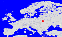
Diese Karte zeigt die Position oder den Umriss des Objekts. Haben Sie einen Fehler entdeckt? Dann würden wir uns über eine Nachricht freuen.
Übergeordnete Objekte
Legende
| | politische Verwaltung |
| | kirchliche Verwaltung |
| | gerichtliche Verwaltung |
| | Wohnplatz |
| | geographische Typen |
| | Verkehrswesen |
Übergeordnete Objekte
- Wolost Chotjatschew, Хотячевская волость (Wolost)
- Ujesd Wladimir-Wolynsk, powiat włodzimierski, Владимиржський уезд, Володимир-Волинський повіт, Владимир-Волынский уезд (Ujesd)
- Wolhynien, Волынь, Волинь (Land)
- Wolhynien, Gubernia wołyńska, Volhynian Governorate, Волынская губерния, Волинська Губернія (Gouvernement)
- Zarentum Russland, Russisches Reich, Tsardom of Russia, Царство Русское, Московське царство, Російська імперія, Imperium Rosyjskie, Russian Empire, Российская Империя (Kaiserreich)
- Ukrainische Sozialistische Sowjetrepublik (USSR), Українська Радянська Соціалістична Республіка (УРСР), Украинская Советская Социалистическая Республика (УССР) (Republik Unionsrepublik)
- Vereinte Nationen, Verenigde Naties, Организация Объединённых Наций, Organisation des Nations unies, 联合国, Organización de las Naciones Unidas, United Nations, الأمم المتحدة, Organizácia Spojených národov (Staatenbund)
- Sowjetunion, Union der Sozialistischen Sowjetrepubliken, UdSSR, Советский Союз, СССР, USSR, Unie van Socialistische Sovjetrepublieken, Soviet Union, Union of Soviet Socialist Republics, Союз Советских Социалистических Республик, USSR (Bundesstaat)
- Russische SFSR, Russland, Russische Föderation, Rusland, Russia, Russian Federation, Russie (la Féderation de), Российская Советская Федеративная Социалистическая Республика (РСФСР), Россия, Российская Федерация (Republik Unionsrepublik Republik)
- Sowjetunion, Union der Sozialistischen Sowjetrepubliken, UdSSR, Советский Союз, СССР, USSR, Unie van Socialistische Sovjetrepublieken, Soviet Union, Union of Soviet Socialist Republics, Союз Советских Социалистических Республик, USSR (Bundesstaat)
- Vereinte Nationen, Verenigde Naties, Организация Объединённых Наций, Organisation des Nations unies, 联合国, Organización de las Naciones Unidas, United Nations, الأمم المتحدة, Organizácia Spojených národov (Staatenbund)
- Rajon Wladimir-Wolynsk, Rejon włodzimierski, Владимир-Волынский р-н, Володимир-Волинський р-н (Rayon)
- Oblast Wolhynien (Luzk), Волинська область (Луцьк), Obwód wołyński (Łuck), Волынская область (Луцк) (Oblast)
- Ukraine, Ukraina, Ukraine, Украина, Oekraïne, Україна, Ukrajina (Republik)
- Ukrainische Sozialistische Sowjetrepublik (USSR), Українська Радянська Соціалістична Республіка (УРСР), Украинская Советская Социалистическая Республика (УССР) (Republik Unionsrepublik)
- Vereinte Nationen, Verenigde Naties, Организация Объединённых Наций, Organisation des Nations unies, 联合国, Organización de las Naciones Unidas, United Nations, الأمم المتحدة, Organizácia Spojených národov (Staatenbund)
- Sowjetunion, Union der Sozialistischen Sowjetrepubliken, UdSSR, Советский Союз, СССР, USSR, Unie van Socialistische Sovjetrepublieken, Soviet Union, Union of Soviet Socialist Republics, Союз Советских Социалистических Республик, USSR (Bundesstaat)
- Kreisgebiet Wladimir Wolynsk (Kreisgebiet)
- Gmina Chotiaczow, gmina Chotiaczów, ґміна Хотячівська, Хотячевская гмина (Landgemeinde PL)
- Rajon Ustyluh, Устилугский р-н, Устилузький р-н (Rayon)
- Oblast Wolhynien (Luzk), Волинська область (Луцьк), Obwód wołyński (Łuck), Волынская область (Луцк) (Oblast)
- Ukraine, Ukraina, Ukraine, Украина, Oekraïne, Україна, Ukrajina (Republik)
- Ukrainische Sozialistische Sowjetrepublik (USSR), Українська Радянська Соціалістична Республіка (УРСР), Украинская Советская Социалистическая Республика (УССР) (Republik Unionsrepublik)
- Vereinte Nationen, Verenigde Naties, Организация Объединённых Наций, Organisation des Nations unies, 联合国, Organización de las Naciones Unidas, United Nations, الأمم المتحدة, Organizácia Spojených národov (Staatenbund)
- Sowjetunion, Union der Sozialistischen Sowjetrepubliken, UdSSR, Советский Союз, СССР, USSR, Unie van Socialistische Sovjetrepublieken, Soviet Union, Union of Soviet Socialist Republics, Союз Советских Социалистических Республик, USSR (Bundesstaat)
- Kreisgebiet Wladimir Wolynsk (Kreisgebiet)
- Saritschanska, Zarichanska, Зарічанська с.-р. (Dorfrat)
Übergeordnete Objekte
| Name |
Zeitraum |
Typ |
Quelle |
|
Wolost Chotjatschew, Хотячевская волость
|
(- 1921) |
Wolost
|
|
|
Rajon Wladimir-Wolynsk, Rejon włodzimierski, Владимир-Волынский р-н, Володимир-Волинський р-н
|
(1957 -) |
Rayon
|
Quelle
Quelle
|
|
Gmina Chotiaczow, gmina Chotiaczów, ґміна Хотячівська, Хотячевская гмина
|
(1921 - 1939) |
Landgemeinde PL
|
Quelle
|
|
Rajon Ustyluh, Устилугский р-н, Устилузький р-н
|
(1940 - 1957) |
Rayon
|
|
|
Saritschanska, Zarichanska, Зарічанська с.-р.
|
|
Dorfrat
|
Quelle
Stand 1.3.2018
|
Quicktext
GROACH_W8602
	has 1906 population 608 sagt source_390660,
	has 1921 population 549 sagt source_406816,
	has 1987 population 84 sagt source_320250,
	has external reference  BLO:32955,
	has from 1991 postal code 44742 sagt source_301456,
	has from 1993-07-01 postal code 96157,
	has name (in deu) Großbirkach,
	has name (in deu) Suchodoly,
	has name (in pol) Suchodoły,
	has name (in rus) Суходолы,
	has name (in ukr) Суходоли,
	has until 1993-06-30 postal code W8602,
	is (in deu) Dorf,
	is (in deu) Pfarrdorf,
	is from 1921 until 1939 part of object_301548 sagt source_406816,
	is from 1940 until 1957 part of object_1266377,
	is from 1957 part of object_290596 sagt source_298640 sagt source_301432,
	is part of object_1142494 sagt source_390584 (Stand 1.3.2018),
	is part of object_320843,
	is until 1921 part of object_393897,
	located at 49.7992°N 10.4904°O,
	located at 50.786°N 24.231°O;