Wegendorf
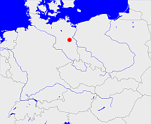
Diese Karte zeigt die Position oder den Umriss des Objekts. Haben Sie einen Fehler entdeckt? Dann würden wir uns über eine Nachricht freuen.
Übergeordnete Objekte
Legende
| | politische Verwaltung |
| | kirchliche Verwaltung |
| | gerichtliche Verwaltung |
| | Wohnplatz |
| | geographische Typen |
| | Verkehrswesen |
Übergeordnete Objekte
- Märkisch-Oderland (Landkreis)
- Brandenburg, Brandenburg, Kraj Bramborska (Bundesland)
- Bundesrepublik Deutschland, Deutschland, Federal Republic of Germany, Герма́ния, Vokietija, Nemecká spolková republika, Germany, Tyskland, Duitsland, Allemagne, Niemcy (Bundesstaat)
- Europäische Wirtschaftsgemeinschaft, Europäische Gemeinschaft, Europäische Union, Evropské hospodářské společenství, Euroopan talousyhteisö, Európske hospodárske spoločenstvo, Communauté économique européenne, Comhphobal Eacnamaíochta na hEorpa, Europese Economische Gemeenschap, European Economic Community, Comunità Economica Europea, Comunidad Económica Europea, Europese Gemeenschap, Evropské společenství, Communauté européenne, Európske spoločenstvo, Comhphobal Eorpach, Comunità Europea, Comunidad Europea, European Community, Euroopan Yhteisö, Evropská unie, Unione Europea, Euroopan Unioni, Aontais Eorpaigh, European Union, Unión Europea, Europese Unie, Union européenne, Európska únia (Staatenbund)
- Vereinte Nationen, Verenigde Naties, Организация Объединённых Наций, Organisation des Nations unies, 联合国, Organización de las Naciones Unidas, United Nations, الأمم المتحدة, Organizácia Spojených národov (Staatenbund)
- Niederbarnim (Kreis Landkreis)
- Buchholz (Amtsbezirk)
- Strausberg (Landkreis)
- Brandenburg, Brandenburg, Kraj Bramborska (Bundesland)
- Bundesrepublik Deutschland, Deutschland, Federal Republic of Germany, Герма́ния, Vokietija, Nemecká spolková republika, Germany, Tyskland, Duitsland, Allemagne, Niemcy (Bundesstaat)
- Europäische Wirtschaftsgemeinschaft, Europäische Gemeinschaft, Europäische Union, Evropské hospodářské společenství, Euroopan talousyhteisö, Európske hospodárske spoločenstvo, Communauté économique européenne, Comhphobal Eacnamaíochta na hEorpa, Europese Economische Gemeenschap, European Economic Community, Comunità Economica Europea, Comunidad Económica Europea, Europese Gemeenschap, Evropské společenství, Communauté européenne, Európske spoločenstvo, Comhphobal Eorpach, Comunità Europea, Comunidad Europea, European Community, Euroopan Yhteisö, Evropská unie, Unione Europea, Euroopan Unioni, Aontais Eorpaigh, European Union, Unión Europea, Europese Unie, Union européenne, Európska únia (Staatenbund)
- Vereinte Nationen, Verenigde Naties, Организация Объединённых Наций, Organisation des Nations unies, 联合国, Organización de las Naciones Unidas, United Nations, الأمم المتحدة, Organizácia Spojených národov (Staatenbund)
- Frankfurt (Bezirk)
- Buchholz (Standesamt)
- Altlandsberg (Amt)
- Strausberg (Landkreis)
- Brandenburg, Brandenburg, Kraj Bramborska (Bundesland)
- Bundesrepublik Deutschland, Deutschland, Federal Republic of Germany, Герма́ния, Vokietija, Nemecká spolková republika, Germany, Tyskland, Duitsland, Allemagne, Niemcy (Bundesstaat)
- Europäische Wirtschaftsgemeinschaft, Europäische Gemeinschaft, Europäische Union, Evropské hospodářské společenství, Euroopan talousyhteisö, Európske hospodárske spoločenstvo, Communauté économique européenne, Comhphobal Eacnamaíochta na hEorpa, Europese Economische Gemeenschap, European Economic Community, Comunità Economica Europea, Comunidad Económica Europea, Europese Gemeenschap, Evropské společenství, Communauté européenne, Európske spoločenstvo, Comhphobal Eorpach, Comunità Europea, Comunidad Europea, European Community, Euroopan Yhteisö, Evropská unie, Unione Europea, Euroopan Unioni, Aontais Eorpaigh, European Union, Unión Europea, Europese Unie, Union européenne, Európska únia (Staatenbund)
- Vereinte Nationen, Verenigde Naties, Организация Объединённых Наций, Organisation des Nations unies, 联合国, Organización de las Naciones Unidas, United Nations, الأمم المتحدة, Organizácia Spojených národov (Staatenbund)
- Frankfurt (Bezirk)
- Märkisch-Oderland (Landkreis)
- Brandenburg, Brandenburg, Kraj Bramborska (Bundesland)
- Bundesrepublik Deutschland, Deutschland, Federal Republic of Germany, Герма́ния, Vokietija, Nemecká spolková republika, Germany, Tyskland, Duitsland, Allemagne, Niemcy (Bundesstaat)
- Europäische Wirtschaftsgemeinschaft, Europäische Gemeinschaft, Europäische Union, Evropské hospodářské společenství, Euroopan talousyhteisö, Európske hospodárske spoločenstvo, Communauté économique européenne, Comhphobal Eacnamaíochta na hEorpa, Europese Economische Gemeenschap, European Economic Community, Comunità Economica Europea, Comunidad Económica Europea, Europese Gemeenschap, Evropské společenství, Communauté européenne, Európske spoločenstvo, Comhphobal Eorpach, Comunità Europea, Comunidad Europea, European Community, Euroopan Yhteisö, Evropská unie, Unione Europea, Euroopan Unioni, Aontais Eorpaigh, European Union, Unión Europea, Europese Unie, Union européenne, Európska únia (Staatenbund)
- Vereinte Nationen, Verenigde Naties, Организация Объединённых Наций, Organisation des Nations unies, 联合国, Organización de las Naciones Unidas, United Nations, الأمم المتحدة, Organizácia Spojených národov (Staatenbund)
- Oberbarnim (Kreis Landkreis)
- Altlandsberg (Amtsgericht)
- Wegendorf (Standesamt)
- Niederbarnim (Kreis Landkreis)
- Strausberg (Landkreis)
- Brandenburg, Brandenburg, Kraj Bramborska (Bundesland)
- Bundesrepublik Deutschland, Deutschland, Federal Republic of Germany, Герма́ния, Vokietija, Nemecká spolková republika, Germany, Tyskland, Duitsland, Allemagne, Niemcy (Bundesstaat)
- Europäische Wirtschaftsgemeinschaft, Europäische Gemeinschaft, Europäische Union, Evropské hospodářské společenství, Euroopan talousyhteisö, Európske hospodárske spoločenstvo, Communauté économique européenne, Comhphobal Eacnamaíochta na hEorpa, Europese Economische Gemeenschap, European Economic Community, Comunità Economica Europea, Comunidad Económica Europea, Europese Gemeenschap, Evropské společenství, Communauté européenne, Európske spoločenstvo, Comhphobal Eorpach, Comunità Europea, Comunidad Europea, European Community, Euroopan Yhteisö, Evropská unie, Unione Europea, Euroopan Unioni, Aontais Eorpaigh, European Union, Unión Europea, Europese Unie, Union européenne, Európska únia (Staatenbund)
- Vereinte Nationen, Verenigde Naties, Организация Объединённых Наций, Organisation des Nations unies, 联合国, Organización de las Naciones Unidas, United Nations, الأمم المتحدة, Organizácia Spojených národov (Staatenbund)
- Frankfurt (Bezirk)
- Alt Landsberg, Altlandsberg (Standesamt)
- Strausberg (Landkreis)
- Brandenburg, Brandenburg, Kraj Bramborska (Bundesland)
- Bundesrepublik Deutschland, Deutschland, Federal Republic of Germany, Герма́ния, Vokietija, Nemecká spolková republika, Germany, Tyskland, Duitsland, Allemagne, Niemcy (Bundesstaat)
- Europäische Wirtschaftsgemeinschaft, Europäische Gemeinschaft, Europäische Union, Evropské hospodářské společenství, Euroopan talousyhteisö, Európske hospodárske spoločenstvo, Communauté économique européenne, Comhphobal Eacnamaíochta na hEorpa, Europese Economische Gemeenschap, European Economic Community, Comunità Economica Europea, Comunidad Económica Europea, Europese Gemeenschap, Evropské společenství, Communauté européenne, Európske spoločenstvo, Comhphobal Eorpach, Comunità Europea, Comunidad Europea, European Community, Euroopan Yhteisö, Evropská unie, Unione Europea, Euroopan Unioni, Aontais Eorpaigh, European Union, Unión Europea, Europese Unie, Union européenne, Európska únia (Staatenbund)
- Vereinte Nationen, Verenigde Naties, Организация Объединённых Наций, Organisation des Nations unies, 联合国, Organización de las Naciones Unidas, United Nations, الأمم المتحدة, Organizácia Spojených národov (Staatenbund)
- Frankfurt (Bezirk)
- Niederbarnim (Kreis Landkreis)
Untergeordnete Objekte
| Name |
Typ |
GOV-Kennung |
Zeitraum |
| Wegendorf |
DorfOrtsteilOrtsteil
|
WEGOR1JO62VO |
(- 1997-12-30) |
| Steinau |
Wohnplatz
|
STENAUJO62UO |
(- 1997-12-30) |
Quicktext
LENINGJN58RT
	has 1875 population 286 sagt source_263605,
	has 1890 population 341 sagt source_263605,
	has 1895-12-02 area 12.512 sagt source_1023281 (S. 34 / 35),
	has 1895-12-02 households 62 sagt source_1023281 (S. 34 / 35),
	has 1895-12-02 population 329 sagt source_1023281 (S. 34 / 35),
	has 1910-12-01 population 314 sagt source_263605 sagt source_265044,
	has 1925 population 297 sagt source_263605,
	has 1933 population 378 sagt source_190312 sagt source_263605,
	has 1939 population 392 sagt source_190312,
	has 1946 population 553 sagt source_284918,
	has 1961 population 1719 sagt source_379404,
	has 1987 population 3730 sagt source_320250,
	has 1993 population 385 sagt source_263605,
	has 1994 population 451 sagt source_263605,
	has 1995 population 504 sagt source_263605,
	has 1996 population 619 sagt source_263605,
	has 2006 population 897 sagt source_284734,
	has URL  https://de.wikipedia.org/wiki/Lenting,
	has external reference  BLO:5519,
	has external reference  geonames:2878751,
	has from 1991-07-01 until 1993-12-05 municipal id 12045370 sagt source_1077051,
	has from 1993-07-01 postal code 15345,
	has from 1993-07-01 postal code 85101,
	has from 1993-12-06 until 1997-12-30 municipal id 12064488 sagt source_290784,
	has name (in deu) Lenting,
	has name (in deu) Wegendorf,
	has until 1993-06-30 postal code O1261,
	has until 1993-06-30 postal code W8071,
	is (in deu) Pfarrdorf,
	is 1895-12-02 part of object_1165018 sagt source_1023281 (S. 34 / 35),
	is 1895-12-02 part of object_285641 sagt source_1023281 (S. 34 / 35),
	is 1952-01-01 part of object_1333274 sagt source_1331591,
	is 1992-12-31 part of object_1154030 sagt source_1331592,
	is from 1874-10-02 part of object_1147228 sagt source_1023281 (S. 34 / 35) sagt source_1331590 sagt source_1335057 (Beilage S. 8 Nr. 17),
	is from 1935-04-01 until 1997-12-30 (in deu) Gemeinde sagt source_1077051 sagt source_190312 sagt source_284918 sagt source_290784,
	is from 1950-07-01 until 1952-07-24 part of object_263366 sagt source_284918 sagt source_298652 (Seite 274),
	is from 1952-07-25 until 1993-12-05 part of adm_142045 sagt source_290784,
	is from 1955-05-28 until 1964-03-01 part of object_406105 sagt source_1048536 (1964 - S. 78),
	is from 1964-03-02 part of object_1194774 sagt source_1048536 (1964 - S. 78),
	is from 1993-06-23 until 1997-12-30 part of object_264395 sagt source_264453 sagt source_290784,
	is from 1993-12-06 until 1997-12-30 part of adm_142064 sagt source_290784,
	is part of object_300569 sagt source_320250,
	is part of object_392073 sagt source_379404 (p. 105),
	is until 1935-03-31 (in deu) Landgemeinde sagt source_1023281 (Nr. 93 Seite 34 / 35) sagt source_265044,
	is until 1950-06-30 part of object_263367 sagt source_1023281 (Seite 34 / 35) sagt source_265044 sagt source_298652 (Seite 274),
	is until 1955-05-27 part of object_151660 sagt source_1048536 (1955 - S. 114),
	located at 48.8095°N 11.4562°O;
