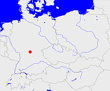
Diese Karte zeigt die Position oder den Umriss des Objekts. Haben Sie einen Fehler entdeckt? Dann würden wir uns über eine Nachricht freuen.
Übergeordnete Objekte
Legende
| | politische Verwaltung |
| | kirchliche Verwaltung |
| | gerichtliche Verwaltung |
| | Wohnplatz |
| | geographische Typen |
| | Verkehrswesen |
Übergeordnete Objekte
- Schweinfurt (Landgericht Amtsgericht)
- Untermainkreis, Unterfranken und Aschaffenburg, Mainfranken, Unterfranken, Lower Franconia (Kreis Regierungsbezirk)
- Bayern, Beieren, Bavaria, Bavière, Бавария (Bundesland)
- Südostzone, US-Besatzungszone, amerikanische Besatzungszone, American Zone of Occupation (Besatzungszone)
- Bundesrepublik Deutschland, Deutschland, Federal Republic of Germany, Герма́ния, Vokietija, Nemecká spolková republika, Germany, Tyskland, Duitsland, Allemagne, Niemcy (Bundesstaat)
- Europäische Wirtschaftsgemeinschaft, Europäische Gemeinschaft, Europäische Union, Evropské hospodářské společenství, Euroopan talousyhteisö, Európske hospodárske spoločenstvo, Communauté économique européenne, Comhphobal Eacnamaíochta na hEorpa, Europese Economische Gemeenschap, European Economic Community, Comunità Economica Europea, Comunidad Económica Europea, Europese Gemeenschap, Evropské společenství, Communauté européenne, Európske spoločenstvo, Comhphobal Eorpach, Comunità Europea, Comunidad Europea, European Community, Euroopan Yhteisö, Evropská unie, Unione Europea, Euroopan Unioni, Aontais Eorpaigh, European Union, Unión Europea, Europese Unie, Union européenne, Európska únia (Staatenbund)
- Vereinte Nationen, Verenigde Naties, Организация Объединённых Наций, Organisation des Nations unies, 联合国, Organización de las Naciones Unidas, United Nations, الأمم المتحدة, Organizácia Spojených národov (Staatenbund)
- Baiern, Pfalz-Baiern, Churpfalz-Baiern, Kurpfalz-Bayern, Bayern, Bavaria (Herzogtum Königreich Freistaat)
Quicktext
DUVEDTJO44TI
	has 1842 population 703,
	has 1880 population 486,
	has 1890 population 474,
	has 1900 population 15302 sagt source_394481 (p. XI),
	has 1900 population 449,
	has 1903 area 24.56 sagt source_394481 (p. XI),
	has 1910 area 24.57 sagt source_1341051 (Tab. III S. 45),
	has 1910 population 22194 sagt source_1341051 (Tab. III S. 44),
	has 1910 population 511,
	has 1921 population 421,
	has 1925 population 36336 sagt source_395211 (p. 14*),
	has 1928 area 32.75 sagt source_395211 (p. 14*),
	has 1930 population 413,
	has 1933 population 40176 sagt source_1267338 (p. 13),
	has 1939 population 321,
	has 1939 population 49321 sagt source_298730 (p. 16),
	has 1941 area 32.77 sagt source_298730 (p. 16),
	has 1950 population 46140 sagt source_394864 (p. 24),
	has 1952 area 32.75 sagt source_394864 (p. 24),
	has 1961 population 217,
	has 1961 population 394 sagt source_379404,
	has 1961 population 56881 sagt source_379404 (Sp. 839),
	has 1961-06-06 population 926 sagt source_1081178 (p. 118),
	has 1964 area 32.8 sagt source_379404 (Sp. 839),
	has 1970 area 32.97 sagt source_1343040 (A S. 18),
	has 1970 population 58390 sagt source_1343040 (A S. 18),
	has 1970-05-27 population 1096 sagt source_1082104 (p. 95),
	has 1987 area 35.87 sagt source_1045014 (p. 109),
	has 1987 population 465 sagt source_320250,
	has 1987 population 51962 sagt source_1045014 (p. 109),
	has 1995 population 55722 sagt source_284814,
	has 2000 population 54325 sagt source_284814,
	has 2004 population 1854 sagt source_268035,
	has 2005 population 54273 sagt source_284814,
	has URL  http://de.wikipedia.org/wiki/Schweinfurt,
	has URL  https://de.wikipedia.org/wiki/Amerbach_(Wemding),
	has external reference  BLO:1526,
	has external reference  BLO:45143,
	has external reference  BLO:87,
	has external reference  NUTS1999:DE262,
	has external reference  NUTS2003:DE262,
	has external reference  geonames:2956568,
	has external reference  geonames:2958016,
	has external reference  wikidata:Q4126,
	has from 1993-07-01 postal code 24791,
	has from 1993-07-01 postal code 86650,
	has from 1993-07-01 postal code 9742.,
	has municipal id 09662000,
	has name (in cze) Húrky,
	has name (in dan) Gammel Duvensted,
	has name (in deu) Adamsfreiheit,
	has name (in deu) Alt Duvenstedt,
	has name (in deu) Amerbach,
	has name (in deu) Schweinfurt,
	has until 1993-06-30 postal code W2371,
	has until 1993-06-30 postal code W8720,
	has until 1993-06-30 postal code W8861,
	is (in deu) Dorf sagt source_1081178 (p. 118) sagt source_1082104 (p. 95),
	is (in deu) Kirchdorf,
	is (in deu) Kreisfreie Stadt,
	is 1890 part of object_185311 sagt source_387809 (p. 31),
	is 1895-12-02 part of object_1088071 sagt source_1023281 (S. 60 / 61),
	is 1895-12-02 part of object_396070 sagt source_1023281 (S. 60 / 61),
	is from 1838-01-01 part of adm_369096,
	is from 1879-10-01 part of object_285627,
	is from 1908 part of BEEKOWJO72DE sagt source_265044 sagt source_284734,
	is from 1938 until 1945 part of object_306019,
	is from 1972-07-01 part of object_300731,
	is from 2000 (in deu) Gemeindeteil,
	is from 2000 part of object_376983,
	is part of object_1089487 sagt source_379404 (Sp. 1009),
	is part of object_307231,
	is part of object_334241 sagt source_1081178 (p. 118) sagt source_1082104 (p. 95) sagt source_387809 (p. 31),
	is part of object_395556 sagt source_379404 (Sp. 1009),
	is until 1908 part of object_1190964,
	is until 1938 part of object_310570,
	is until 1972-06-30 part of AMEACH_W8861,
	is until 1974 (in deu) Marktgemeinde,
	located at 48.8879°N 10.6988°O,
	located at 52.1622°N 14.2511°O 45m,
	located at 54.37°N 9.65°O;
